Interested In This Footage?
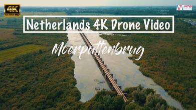
The Historical Moerputten Bridge in Noord Brabant - Netherlands 4K Drone Video
- over 4 years ago
- 957 VŪZ
12 


- 9
- Report

This beautiful historical site has a deep connection to NTG Drone Media. This place where the NTG Drone Media idea was found back in 2017. It was just a normal walk to spend our relaxing day at that time until we talked a lot about the future as that time I was still looking for a way to share all of my drone flight documentations. Short story we decided to create our sharing media which is called NTG Drone Media now. Thank you to all of our supporters, we are exist because of you all guys and we want to grow even bigger in the years to come. 🙏🏽 A short story about the Moerputten bridge Credit to Wikipedia https://en.wikipedia.org/wiki/Moerputten_Bridge Moerputten Bridge is located in the area between 's-Hertogenbosch and Vlijmen. Before World War II this was regularly flooded by the overflows in the Meuse dykes. An overflow is a stretch of dyke that is intentionally left lower than other sections. At exceptional or seasonal high water levels, it overflows and relieves the pressure on other dykes, thereby preventing these from breaking. East of Vlijmen, water would enter the area from the seasonal river Beerse Maas, which was caused by the Beerse Overlaat near Grave. It led to water entering the area from the north, and sometimes from south of 's-Hertogenbosch. The second overflow that regularly flooded the area was the Bokhoven Overflow, even though it could also be used as an exit for the Beerse Maas. In January 1880 water from the Bokhoven Overflow entered the area with such force that the big bridge before the Vughterpoort (Vught gate) south of 's-Hertogenbosch was flushed away. From the first plans for the railroad, it was clear that in order to cross the area, the railroad would have to be constructed on a high solid dyke. This dyke could not be allowed to block the flood plain of the overflows, because that would necessitate reinforcement of dykes in a very wide area. Therefore, the railroad would need to be constructed with so many openings that the overflows could flood the land without obstruction. (contact me here: ntgdronemedia@gmail.com)
Up Next
North-Brabant, The Netherlands

- NTG DRONE
- 908 VŪZ
8 - 6
- about 3 years ago
Pettelaarse Schans 's-Hertogenbosch | The Netherlands Drone Video - Europe in 4K
- NTG DRONE
- 766 VŪZ
14 - 9
- about 7 years ago
Klundert (Noord-Brabant) in 4K | Drone video

- XL Creations
- 1.9k VŪZ
31 - 15
- about 9 years ago
[DRONE VIDEO] De Moerputten, 'S-HERTOGENBOSCH 4K - DJI Mavic Pro Drone Footage 2017
- wildwithchris
- 754 VŪZ
15 - 11
- over 8 years ago
Noord Brabant, Netherlands Drone Video 4K
- NTG DRONE
- 560 VŪZ
8 - 6
- over 7 years ago
Kanaalpark Rosmalen near the Máxima Canal Den Bosch | Netherlands Drone Video - Europe in 4K
- NTG DRONE
- 555 VŪZ
9 - 6
- about 7 years ago
Zeelandbrug (Zierikzee) in 4K
- XL Creations
- 4.0k VŪZ
37 - 20
- over 9 years ago
Earth, Wind & Water - Netherlands

- jeroenpardon
- 1.2k VŪZ
8 - 14
- over 4 years ago
A Modern Ruin of Castle Almere, the Netherlands
- NTG DRONE
- 639 VŪZ
8 - 5
- about 4 years ago
Lisse from above 4k | Dutch flower fields

- BvdB Productions
- 826 VŪZ
12 - 12
- about 6 years ago