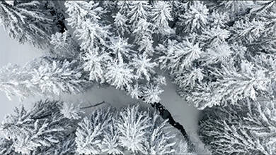
TDHS Top Down Haute Savoie
- about 6 years ago
- 978 VŪZ
11 


- 16
- Report
TDHS is a 50 seconds video consisting of only topdown aerial shots where you follow a character walking through a snowy path. While he walks you’ll discover different winter landscapes that will progressively be revealed. At the end of his journey you’ll noticed the character will continue his way through the snow from his starting point.
Up Next
Autoplay
Glaciers des Sources de l'Arcs, 3262m, Haute Maurienne. Savoie.

- Valentino
- 919 VŪZ
15 - 10
- almost 9 years ago
WINTER FPV - Haute Savoie

- Bastien Nvs
- 799 VŪZ
9 - 6
- over 3 years ago
My Favorite Cliff

- Arnaud Lesueur
- 1.9k VŪZ
15 - 17
- almost 3 years ago
Winterland | FPV x hero 11
- Arnaud Lesueur
- 521 VŪZ
4 - 4
- over 3 years ago

Trip To France (Alpes-de-Haute-Provence, Savoie) 2022 I DJI Mini 2

- jesse_l
- 1.1k VŪZ
4 - 3
- almost 4 years ago
Trail Face Near Mont Blanc with DJI Mavic Pro

- pierrethiaville
- 1.7k VŪZ
42 - 29
- over 8 years ago
Les Grands Moulins, 2498m. Massif de Belledonne, Savoie.
- Valentino
- 1.2k VŪZ
26 - 11
- almost 9 years ago
Pont de la Caille

- Eric GARNIER
- 1.9k VŪZ
8 - 9
- over 4 years ago
Randonnée au Trou de la Mouche dans le massif des Aravis
- LionelTardy
- 535 VŪZ
8 - 8
- almost 8 years ago