Saguaro Forest Flight to Owl Head
AIRVŪZ STAFF NOTE :
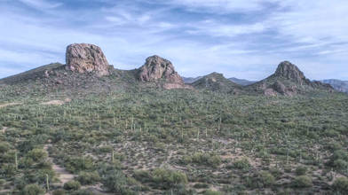
The United States and Mexico share two deserts, both of which are amongst the world's 15 largest: the Chihuahuan and Sonoran Deserts both straddle the two countries' long border. The Sonoran covers about 300k square km (around 120k square mi.) in the states of California, Arizona, and New Mexico on the USA (northern) side and the states of Sonora and Baja California on the Mexico (southern) side. In this drone video by contributor and pilot AZGeek, you'll get a look at the Sonoran Desert just northwest of Tucson in Arizona.
- about 9 years ago
- 1.6k VŪZ
18 


- 13
- Report
BADGES THIS VIDEO HAS EARNED:

A short video of flying a Phantom 4 Pro over a forest of saguaro cacti in the Sonoran desert northwest of Tucson, AZ.
Up Next
Autoplay
Catalina Highway, Tucson, AZ, Phantom 4 Pro

- azgeek
- 1.8k VŪZ
22 - 18
- about 9 years ago
Mavic 2 Pro Flight on Mt. Lemmon
- azgeek
- 1.4k VŪZ
17 - 18
- almost 8 years ago
Reddington Sunrise
- azgeek
- 1.0k VŪZ
10 - 12
- over 7 years ago
Solar Eclipse Trip Aerial Highlights in 4K
- azgeek
- 1.5k VŪZ
20 - 30
- almost 9 years ago
This is Fall in Vermont - Foliage in the Groton State Forest

- Green Mountain Drone
- 7.0k VŪZ
104 - 92
- over 9 years ago
Picacho Peak from Mavic Pro 2
- azgeek
- 744 VŪZ
10 - 9
- over 7 years ago
Cathedral Cliff, San Juan County, New Mexico
- azgeek
- 1.4k VŪZ
20 - 16
- almost 7 years ago
Ancient Volcanoes
- azgeek
- 1.7k VŪZ
17 - 19
- over 7 years ago
Wild Horses on the River

- flyhighaz
- 2.2k VŪZ
5 - 3
- almost 5 years ago
Eroded Landscapes
- azgeek
- 1.2k VŪZ
16 - 19
- over 7 years ago