Mt. Agung Eruption 27.11. 2017
AIRVŪZ STAFF NOTE :
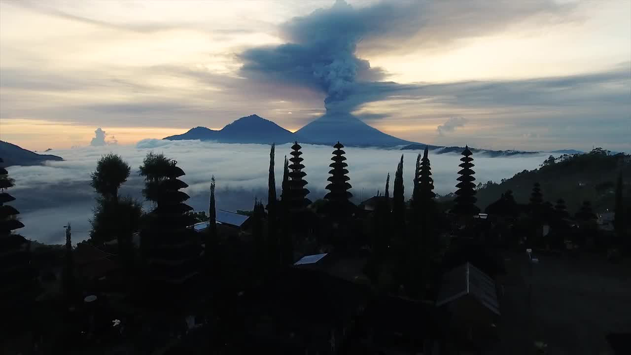
Top contributor Sky Marshall was able to aerially capture the eruption of Mt. Agung on the Indonesian island of Bali. Located in the east-central part of the island, Agung is the tallest mountain on the island, with a peak elevation of just over 3k meters (just under 10k ft.). The volcano is quite active, having erupted spectacularly in 1963-4, killing over a thousand people. Its most recent activity beginning in 2017 has not been as dramatic, but nevertheless is considered quite threatening.
- over 8 years ago
- 1.4k VŪZ
18 


- 14
- Report
BADGES THIS VIDEO HAS EARNED:

Mt. Agung started eruption 25.11. evening. This footage is from 27.11. morning. Filmed with DJI Phantom 4 from Pura Ulun Sanu Batur, Kintamani, Bali, Indonesia. Stay tuned, this is gonna be a big one!
Up Next
Autoplay
Mount Agung, Bali, Indonesia - 4K

- landscapesUHD
- 1.4k VŪZ
12 - 8
- over 3 years ago
Bali - Mt AGUNG & BATUR - timelapse/drone video

- Travel Imagez
- 1.6k VŪZ
4 - 6
- about 4 years ago
40 Years After The Eruption [4K Drone over Mt. St. Helens)

- brotherstouring
- 1.4k VŪZ
11 - 12
- almost 6 years ago
Markus Schulz presents Dakota - The Ninth Sky | Official Music Video

- Sky Marshal
- 713 VŪZ
10 - 6
- over 8 years ago
Mt. Bromo Eruption in Indonesia

- DiamondSky
- 5.0k VŪZ
43 - 46
- over 6 years ago
Sicily's Mount Etna in 4k

- Chris Borg
- 3.0k VŪZ
53 - 51
- over 8 years ago
Mt. Batur / 8°14′20″S 115°22′39″E

- chrissbergan
- 1.6k VŪZ
14 - 11
- almost 3 years ago
Inspire 1 at Bunaken Island
- Sky Marshal
- 4.9k VŪZ
13 - 10
- about 9 years ago
Mt. Rinjani: Lombok Volcano

- CLOUDS TRIP
- 516 VŪZ
14 - 7
- almost 8 years ago
Showreel 2015
- Sky Marshal
- 1.9k VŪZ
18 - 12
- about 9 years ago