DJI Mavic Pro over Ma Shi Chau - 香港馬屎洲三門仔航拍 14Feb2017
- over 9 years ago
- 1.6k VŪZ
13 


- 12
- Report

香港馬屎洲三門仔航拍 (Mavic Pro)
Background music : 春の向日葵 – www.tam-music.com
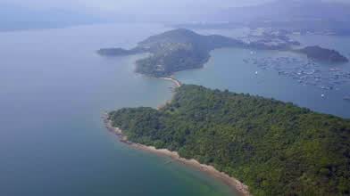
Ma Shi Chau has an area of 0.61 km2. It is part of the Ma Shi Chau Special Area, as it exhibits tombolo and tide features rarely seen in Hong Kong. It is the largest island of the four in the Special Area, the others being Yeung Chau, Centre Island and an unnamed island near Yim Tin Tsai.
It has sedimentary rock dating back to the Permian period that is protected by its Special Area status.
馬屎洲面積共61公頃,範圍涵蓋吐露港內的馬屎洲、洋洲、丫洲及三門仔新村東北面的一個未命名島嶼。馬屎洲是香港二疊紀「大埔海組」的要址,島上岩石露頭出露良好,加上存在斷層和褶皺構造,岩層亦發生變形或錯斷,形態複雜,因此最適合研究地層、岩性、沉積特徵和各類地質構造。
Yim Tin Tsai is located in Tolo Harbour and forms part of the southern border of Plover Cove. It is connected to the mainland in the north by a road, leading next to The Beverly Hills, and to the island of Ma Shi Chau in the east by a tombolo[1] that is only accessible when the tide is low.
三門仔是香港新界大埔區一地方,位於大埔區鹽田仔,鄰近沙欄比華利山別墅,其東是船灣海,南面則連接馬屎洲,為區內最具規模的漁村,現時該處仍保留著濃厚的漁村風味。村民主要是蜑家人(即水上人)居住,村民大多姓何、方、陳、石、張為主。三門仔亦是個避風塘,對出是三門仔漁排。
Up Next
DJI Mavic Pro over Three Fathoms Cove-企嶺下海航拍 23Sep2017

- Bryant.Drone
- 632 VŪZ
9 - 11
- over 8 years ago
DJI Mavic Pro over Aberdeen Reservoir-香港仔水塘航拍 11Aug2017
- Bryant.Drone
- 1.6k VŪZ
19 - 25
- almost 9 years ago
DJI Mavic Pro over Violet hill - 香港紫羅蘭山航拍 20Feb2017
- Bryant.Drone
- 1.9k VŪZ
24 - 21
- over 9 years ago
DJI Mavic Pro over Dragon's Back-香港龍脊航拍 2July2017
- Bryant.Drone
- 2.0k VŪZ
19 - 20
- almost 9 years ago
DJI Mavic Pro over Mount High West - 香港西高山航拍 17June2017
- Bryant.Drone
- 1.6k VŪZ
17 - 16
- almost 9 years ago
DJI Mavic Pro over Castle Peak -青山航拍 4April2018
- Bryant.Drone
- 928 VŪZ
10 - 14
- about 8 years ago
DJI Phantom 3 over Kowloon Reservoir - 香港航九龍水塘拍 17Dec2016
- Bryant.Drone
- 827 VŪZ
12 - 5
- over 9 years ago
DJI Mavic Pro over Ho Pui Reservoir - 香港河背水塘航拍 1May2017
- Bryant.Drone
- 1.8k VŪZ
16 - 15
- about 9 years ago
DJI Mavic Pro over Cape D'Aguilar-鶴咀航拍 27Aug2017
- Bryant.Drone
- 1.0k VŪZ
15 - 19
- almost 9 years ago
2017 Compilation (4k) Perfect Ending Dji Mavic Pro

- minglam
- 1.2k VŪZ
27 - 30
- over 8 years ago