AGUARONGO PROTECTED FOREST
- over 8 years ago
- 110 VŪZ
8 


- 4
- Report

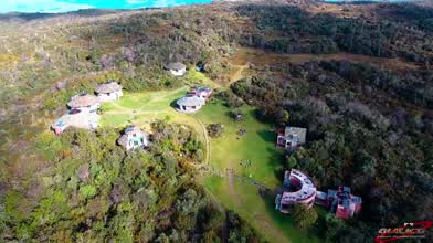
The protected forest Aguarongo, word of Quichua origin to denominate the plant of scientific name Puya clava-herculis, a bromelia typical of the moors of the southern Ecuador, well-known also like the Achupalla. The Aguarongo is a montane forest, characterized by Scrub that form a narrowly dense canopy. It is located to the east of the city of Cuenca inside the parish Jadán, with an extension of 2080 hectars and an average altitude of 3100 MASL. The protected forest Aguarongo is an island in the middle of the inter-Andean valley, within the Paute River basin, whose strategic location has allowed the protection of several species of birds, mammals and amphibians. It is also scenery to enjoy the surrounding landscape, which allows us to look at symbolic elevations of both the Western and Eastern Andean mountains. Music: Fraile Pintado (Painted Friar) - Jorge M. Calandrelli Video: DJI Phantom 4, Origin: 3840x2160p, 29.97p, Output: 3840x2160p, 30p.
Up Next
QUITAHUAYCO: THE INDOMITABLE VALLEY

- QUILICO DRONES
- 2.5k VŪZ
21 - 16
- over 8 years ago
Georgia National Parks
- Travel With Us
- 1.3k VŪZ
18 - 18
- over 7 years ago
Breather in the Sunshine of Tikranaloma
- QUILICO DRONES
- 2.5k VŪZ
26 - 20
- over 8 years ago
THE GREAT OSOHUAYCO LAKE
- QUILICO DRONES
- 1.8k VŪZ
12 - 13
- over 8 years ago
EL CAJAS: MEMORIES OF A HIKER
- QUILICO DRONES
- 980 VŪZ
14 - 7
- over 7 years ago
ARQUITECTOS: HIGHEST SUMMIT OF CAJAS NATIONAL PARK
- QUILICO DRONES
- 1.4k VŪZ
11 - 11
- over 8 years ago
LAGARTOCOCHA: IN THE HEART OF CAJAS NATIONAL PARK
- QUILICO DRONES
- 2.2k VŪZ
12 - 16
- over 8 years ago
Middlemost Andes of Ecuador
- QUILICO DRONES
- 2.8k VŪZ
36 - 24
- almost 8 years ago
DIABLOSCOCHA MOUNTAIN: THE MEPHISTO OF THE CAJAS PLATEAU
- QUILICO DRONES
- 2.9k VŪZ
11 - 7
- over 8 years ago
PLAYAS ENCANTADAS (ENCHANTED SHORES)
- QUILICO DRONES
- 837 VŪZ
18 - 13
- over 8 years ago