Drones Eye View: The Power of the Forces that Shape the Earth
AIRVŪZ STAFF NOTE :
The San Andreas Fault is one of the most famous cracks in the earth. It's boundary between the North American and Pacific tectonic plates, which periodically slide across each other and release gigantic amounts of destructive energy in the form of earthquakes, including the one which nearly destroyed the city of San Francisco in 1906. In this drone video by Allan Crawford, you'll get an aerial view of the fault as it runs along the Corrizo Plain in the center of California, about 270 mi. (around 430 km) southeast of San Francisco.
- about 3 years ago
- 1.9k VŪZ
15 


- 13
- Report

BADGES THIS VIDEO HAS EARNED:

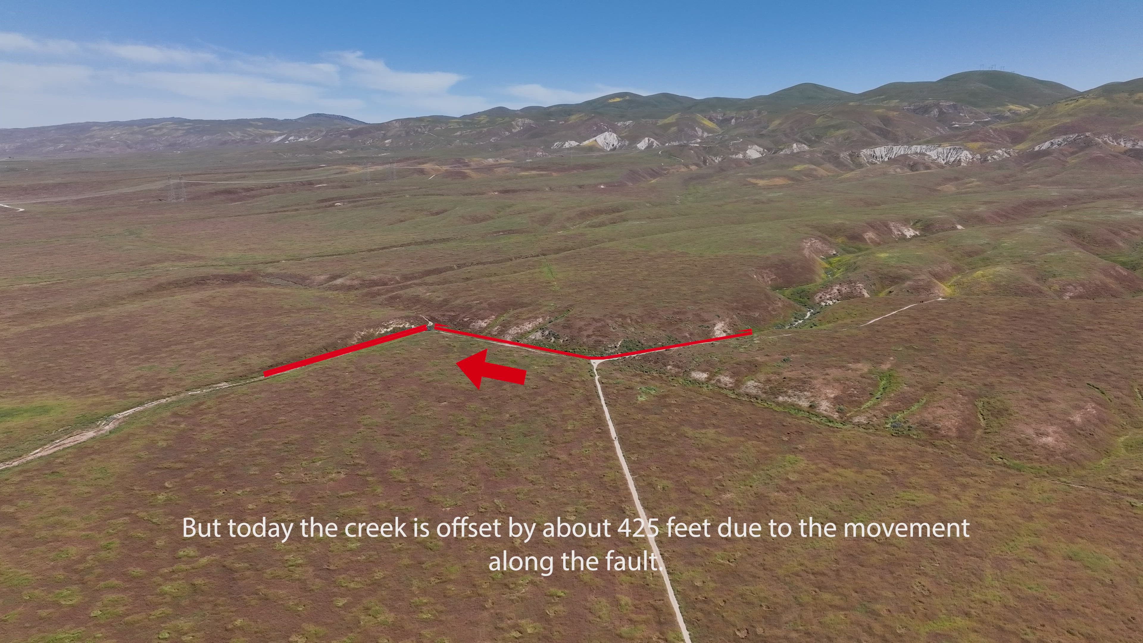
The San Andres Fault is one of the most spectacular geologic features on earth, being clearly visible from space. And from a drone. While most people are familiar with the earthquakes that are associated with the San Andres Fault and the potential "big one", you can get a close look at the fault see how it is shaping the landscape around us in Carrizo Plain of Central California. Here you can see the direct results of the movement along the fault by examining the offset along Wallace Creek. Over the past 3,800 years the creek, which flows perpendicular to the fault, has been offset by over 400 feet due to the repeated movement along the fault. While on average the movement along the fault is about 1.5 inches per year, the movement isn't continuous. It's episodic and often catastrophic. In 1858 the estimated 7.9 magnitude Tejon Earthquake resulted in nearly 24 feet of lateral movement. Around 1600 an even larger quake resulted in movement of over 40 feet. In comparison the 1989 San Francisco Quake was a magnitude 6.9. What is key is that the scale is logarithmic...thus the 7.9 quake was 10x as strong as the San Francisco Quake. The spectacular offset along Wallace Creek shows the power of the forces that are shaping the earth around us, and foreshadows what we know is to come.
Up Next
Road to Hana Waterfalls
- Allan Crawford
- 906 VŪZ
14 - 7
- over 7 years ago
Cranes, lights and sunsets - Port of Long Beach
- Allan Crawford
- 876 VŪZ
12 - 10
- over 6 years ago
Between the Storms: Seattle
- Allan Crawford
- 647 VŪZ
8 - 9
- about 3 years ago
Nigardsbreen (Glacier), Jostedalsbreen National Park, Norway
- Allan Crawford
- 1.8k VŪZ
24 - 15
- almost 7 years ago
Over The Glacier | Cinematic Drone

- rinosanto
- 2.0k VŪZ
2 - 2
- almost 3 years ago
Donner Pass: winter wonderland
- Allan Crawford
- 1.6k VŪZ
15 - 9
- over 5 years ago
Kolob Terrace: Zion National Park
- Allan Crawford
- 1.5k VŪZ
10 - 7
- over 2 years ago
Earth Day

- VolcaDrone Product...
- 1.9k VŪZ
6 - 6
- about 3 years ago
Fall Beauty of Mono Lake
- Allan Crawford
- 576 VŪZ
15 - 9
- over 6 years ago
Toledo, Spain: A UNESCO World Heritage Site
- Allan Crawford
- 2.8k VŪZ
15 - 9
- over 7 years ago