The Mexican Hat, Utah
AIRVŪZ STAFF NOTE :
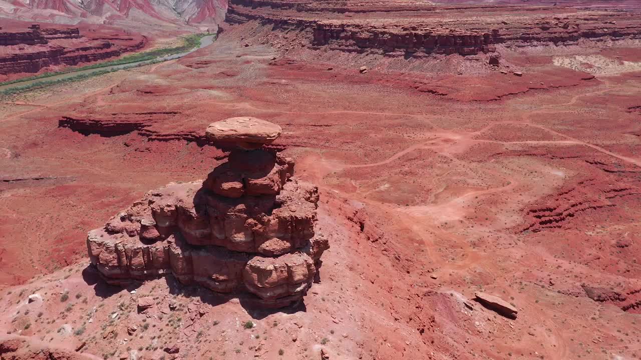
Contributor and pilot Michael McColl created this excellent drone video of a well-known rock formation in the Southwestern USA called Mexican Hat. It derives its name from its sombrero shape, which you'll see clearly in the video. The rock can be climbed via two separate routes. The rock (and the town which is named after it) are located near the San Juan River in San Juan County, which lies in the southeastern corner of Utah, not far from the Four Corners area where Utah touches three other states.
- almost 7 years ago
- 827 VŪZ
9 


- 8
- Report
BADGES THIS VIDEO HAS EARNED:

The name "Mexican Hat" comes from a curiously sombrero-shaped rock outcropping on the northeast edge of town; the rock measures 60-foot (18 m) wide by 12-foot (3.7 m). The "Hat" has two rock climbing routes ascending it.
Up Next
Autoplay
Four Corners Red Rocks

- dmjpix:)
- 1.9k VŪZ
8 - 11
- about 4 years ago
'Scuse Me While I Kiss the Sky

- Hayden Kast
- 541 VŪZ
13 - 9
- about 7 years ago
Southern Utah’s Valley of the Gods 4K Highlight Reel
- azgeek
- 1.7k VŪZ
31 - 32
- over 8 years ago
Monument Valley Utah

- NGreyTravels
- 1.7k VŪZ
20 - 10
- about 7 years ago
Solar Eclipse Trip Aerial Highlights in 4K
- azgeek
- 1.5k VŪZ
20 - 30
- almost 9 years ago
Drone and Tonle Bati Temple, Cambodia
- Michael McColl
- 981 VŪZ
17 - 9
- about 8 years ago
Nine Arches Bridge - Ella, Sri Lanka
- Michael McColl
- 1.4k VŪZ
10 - 8
- almost 7 years ago
Rice Field - Bohol , Philippines
- Michael McColl
- 2.0k VŪZ
17 - 10
- about 9 years ago
Loboc Jungle River Resort - Philippines
- Michael McColl
- 1.1k VŪZ
16 - 7
- about 9 years ago
China Mans Hat with the Mavic Pro in 2.7 k 30 FPS

- reggiesurfsax
- 2.5k VŪZ
30 - 14
- about 9 years ago