Interested In This Footage?
Monte Louro
- over 2 years ago
- 538 VŪZ
10 


- 8
- Report

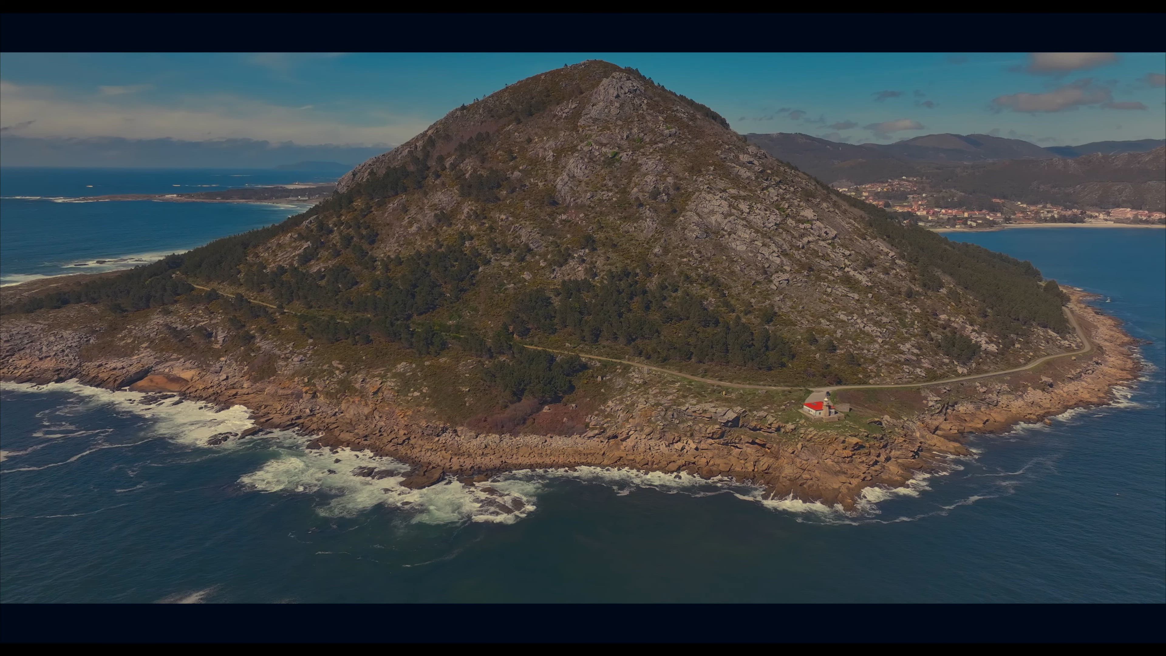
Mount Louro, in the municipality of Muros(A Coruña), is one of the most spectacular viewpoints in Galicia. It emerges in the sea, only connected to the land by a tail of marshes. From the crown of this mountain, 240 meters high, you can see sandbanks, pine forests and very particular rock formations. It is not in vain that the space is recognized as a Place of Interest by the Geological and Mining Institute of Spain.
From the center of the Concello de Muros, you have to go to Punta do Sin Sal, next to Fogareiro beach, where you can park. This is the foothills of Mount Louro. Looking for the Atlantic, after a 20-minute walk with the fullness of the estuary on the left, a small lighthouse appears at the so-called Punta Queixal. If the walker wants to avoid this first journey, which is just over a kilometer and a half, they can also get here by car.
The asphalt ends at this point. The path, now dirt, continues bordering the peninsula formed by the mountain while ascending little by little. Immediately you can see the Area Maior sandy area, also called Louro, with fine white sand and 1,400 meters long. Surfers are regulars at this beach because of its waves, water quality, spaciousness and beauty, so they are another diversion for the visitor.
The higher you go, the better you can see the beach and the lagoon of As Xarfas, a group that forms the isthmus that connects the mountain with the mainland. And Louro is what is known, in geomorphic terms, as a mountain-island or inselberg. That is to say, it is a mountain with a certain slope and a rounded top that appears isolated. They are common in arid areas and especially on the African continent and not so much in Western Europe.
The marshes of the lagoon are home to all types of amphibians and insects that attract birds as elegant as herons. In times of abundant rain, the water overflows and runs to meet the sea, forming a true river that breaks the sand in its path.
Up Next
Ría de Vigo

- Airviewstudio
- 1.2k VŪZ
7 - 10
- over 1 year ago
🌊 Costa da Vela desde el aire 🚁 | Donón, Cabo Home, playas de Melide y Barra (Pontevedra)
- Airviewstudio
- 682 VŪZ
6 - 11
- about 2 months ago
Discovering Portugal 🇵🇹 | Guimaraês And Braga | Cinematic Drone 4K
- Airviewstudio
- 799 VŪZ
8 - 4
- over 2 years ago
Mirador de Cotorredondo | Costa da Vela
- Airviewstudio
- 627 VŪZ
4 - 2
- over 2 years ago
My Year 2024
- Airviewstudio
- 567 VŪZ
1 - 1
- over 1 year ago
Viana do Castelo 🇵🇹
- Airviewstudio
- 715 VŪZ
6 - 6
- about 1 year ago
Summer in Portugal
- Airviewstudio
- 806 VŪZ
5 - 4
- almost 2 years ago
Viana From Above
- Airviewstudio
- 698 VŪZ
6 - 3
- 10 months ago
MY YEAR 2023 | CASTILLA Y LEÓN
- Airviewstudio
- 935 VŪZ
4 - 2
- over 2 years ago
A Trip Through Portugal | Porto & Vila Nova de Gaia
- Airviewstudio
- 679 VŪZ
5 - 4
- almost 2 years ago